How to Read The Weather without a Forecast
You'll need it one day.

A few years ago, my family lived through an F3 tornado.
It passed right by us.
Even now, this feels like an exaggeration, but it’s not. Even while sitting there in the bathroom of our one-level home, having gone through dozens of tornado warnings and storms, something felt different. I’ve gone online and traced its path, and we got lucky. A few streets over, and we might not be here. So, that was a wakeup call. Our prepping wasn’t theoretical anymore.
About three years ago, my family lived through an F3 tornado. It almost destroyed our hometown, injuring hundreds and bringing life to a standstill. For some, it knocked out power for days. People we knew lost their homes.
Last year’s deep, reckless, sinister cuts to the National Weather Service made one thing very clear: As the climate crisis upends our world and brings evermore intense threats to our doors, the super-rich and their political puppets intend to strip us of the tools we need to protect ourselves. And while it’s true that public pressure and legal action forced the current regime to reverse course and approve hires that offset the worst losses from the DOGE cuts, it’s also true that the agency is still recovering—and it’s never going to be quite the same. It’s also true that longterm cuts and efforts to decimate public services will never stop.
It's fitting for those of us interested in dealing with reality and preparing for the future to bring that down into the most concrete levels, learning how to predict bad weather before it hits us.
That's the whole point.
No matter how much we resist, one other basic truth remains. It’s in our interest to know how to deal with disasters when we can’t rely on local or federal leadership. That’s been the theme of my work for a couple of years.
So, reading the weather without a forecast?
Where do you even start?
Learn how to read a barometer
A barometer could save your life. It gives you one of the most reliable ways to predict severe weather ahead of time. Some of us barely know what a barometer does. Well, it measures atmospheric pressure, and atmospheric pressure indicates the conditions that favor severe storms and tornadoes.
This article does a good job explaining how and why barometers can help us predict the weather. In simple terms, barometers rise during dry weather, indicating high pressure and little chance for rain or storms.
When they fall, the chances of bad weather rise.
If you go out and get a barometer, you’ll need to adjust it to your local elevation. You can do that manually, or you can get a fancy digital barometer that adjusts the elevation for you. It might even be a good idea to get a watch that reads barometric pressure, so you’ve always got it on.
A pressure reading above 1013.25 millibars (mb) or hectopascals (hPA) provides the baseline meteorologists use. A barometer might use mb or hPA, but they’re the same. For once, you don’t have to do any conversions
Barometers drop when the pressure does. So a falling barometer indicates a higher chance for rain and storms. The faster a barometer drops, the better the chances for severe weather. A pressure reading that falls below 1009 mb indicates a stronger chance of rain and storms. If the barometer drops 4 mb or more over the course of three hours, that increases the chances even more.
A barometer will tend to gradually fall for 12 hours straight before a storm rolls in. If it falls slower, that tends to indicate a warm front moving in. If it falls faster, that tends to indicate a cold front. Either one can mean storms.
You can be pretty sure of a major storm if:
- Your barometer falls 8 mb or more over 12 hours
- Your barometer drops below 1009 mb
- It heads to 1005 mb or below
- It keeps dropping
Sudden rises in barometric pressure can also mean trouble. If a barometer swings up 6-10 mb over the course of a few hours, that tends to indicate strong winds. Strong winds and dry weather can fuel wildfires. That’s why you pay attention to sudden changes in a barometer in either direction.
It’s a good tool to have.
Stir your coffee
It’s a bit of folklore, but apparently it works pretty well. Make a strong pot of coffee. Pour it into your cup. Stir it until bubbles form. If the bubbles gather in the center, that indicates high pressure and decent weather. If the bubbles move to the walls of the cup, that indicates lower pressure and bad weather.
Pay attention to the wind
According to hikers and farming records, the direction of the wind can provide you with clues about the weather. Winds from the south indicate rain. Winds from the east also indicate rain and bad weather. Strong winds followed by a sudden calm indicate a major storm close at hand.
Do the dew
Heavy dew or fog in the morning or evening indicates decent weather for the next 12 hours. So does frost, during the winter.
Look at the sun and the moon
Haze around the sun or moon at night often predicts rain and storms the next day. A red or hazy moon often indicates dust pushed in from low-pressure systems. On the other hand, a red sun at sunset predicts good weather.
Look at the clouds
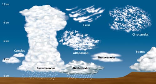
Clouds can tell you a lot about the immediate weather you’re facing. Thin, white clouds usually mean decent weather. So do flat clouds. Flat gray sheets of clouds can mean rain and storms, but generally not severe ones. Fluffy clouds shaped like an anvil often mean major storms are forming. A range of cloud types:
Cumulus: Cauliflower clouds that signal good weather
Cirrocumulus: Small, white, patchy clouds that signal cold weather
Altocumulus: Grayish white sheets that signal potential storms
Stratocumulus: Lumpy gray clouds that signal rain
Cirrus: Feathery clouds that signal decent weather
Cirrostratus: Sheets of clouds that signal rain or snow
Altostratus: Thicker, lower, darker sheets that signal warm fronts
Nimbus/Nimbostratus: Fluffy dark clouds that signal rain
Cumulonimbus: Towering clouds often shaped like anvils that signal strong storms. Of all the cloud types, these mean the most trouble.
Start a fire
Smoke behaves differently during high and low pressure. During high pressure, smoke rises straight into the air. During low pressure, it wafts and spirals back down. A smoky fire often predicts bad weather.
Look at the plants and trees
Flowers tend to close up as rain and storms approach, especially common ones like dandelions and tulips. Pine cones open during dry weather and close during humid weather, as rain approaches. During high humidity, leaves will also tend to go limp and turn over more easily, blown by the wind. In general, vegetation gives off stronger scents during impending rainfall.
Look at the animals and insects
Many animals and insects can sense changes in barometric pressure. Cows lie down together in groups. Birds fly closer to the ground. Frogs get louder. Some insects, like cicadas, flies, and mosquitoes, also get louder and more active before a storm. Of course, it can go either way. You’ll also find advice out there saying that flying insects like butterflies and bees get quiet and shelter down before a storm. You’ll also see contradictory statements that cicadas quiet down their mating calls before a storm. In general, it makes more sense for insects sensing barometric pressure to go quiet and disappear, moving to safer locations.
Other ideas?
I’ll be adding this information to the next major update to the guide. In the meantime, if you know other ways to predict the weather, drop a line in the comments. The more information we have, the better.
